⚠️ 以下所有内容总结都来自于 大语言模型的能力,如有错误,仅供参考,谨慎使用
🔴 请注意:千万不要用于严肃的学术场景,只能用于论文阅读前的初筛!
💗 如果您觉得我们的项目对您有帮助 ChatPaperFree ,还请您给我们一些鼓励!⭐️ HuggingFace免费体验
2025-05-15 更新
Unsupervised Urban Land Use Mapping with Street View Contrastive Clustering and a Geographical Prior
Authors:Lin Che, Yizi Chen, Tanhua Jin, Martin Raubal, Konrad Schindler, Peter Kiefer
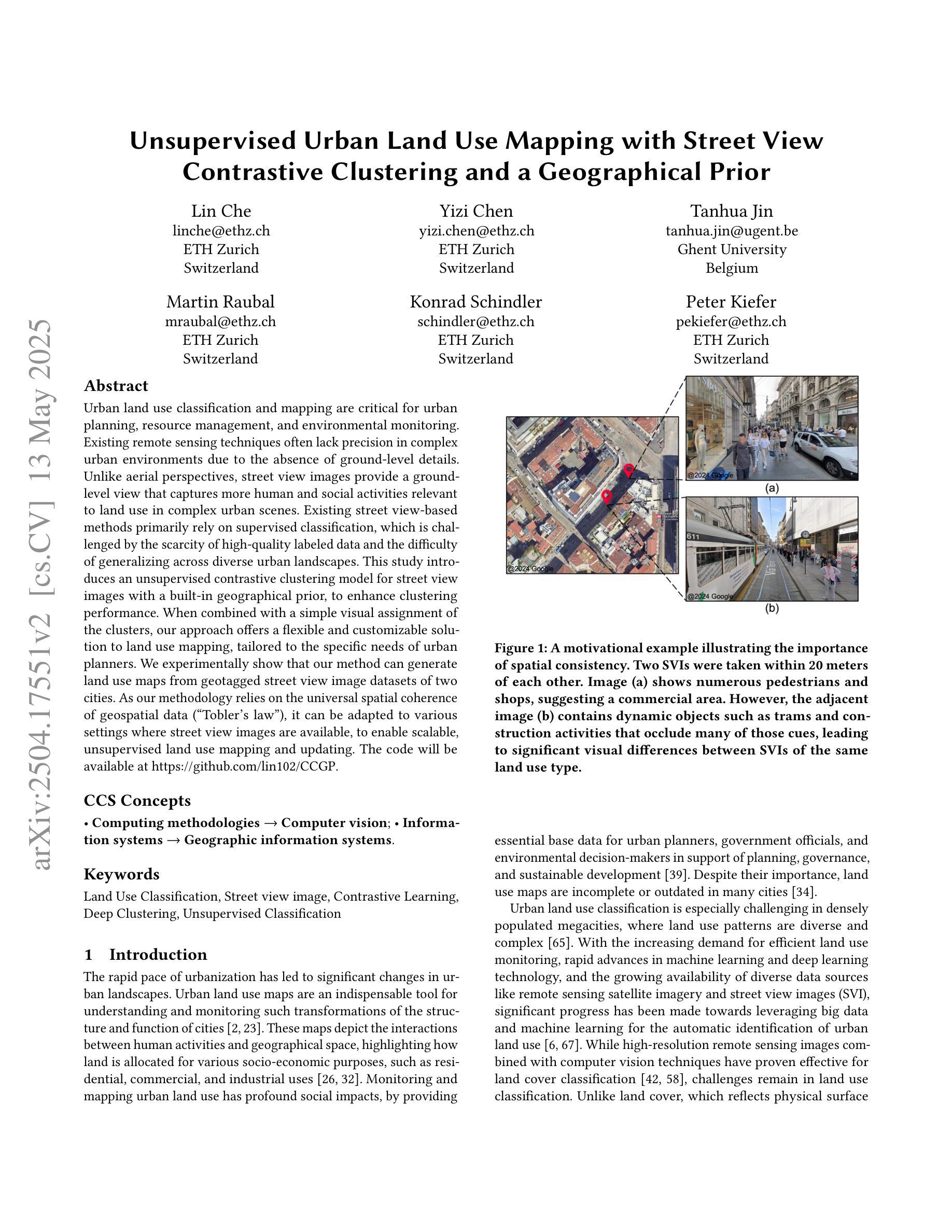
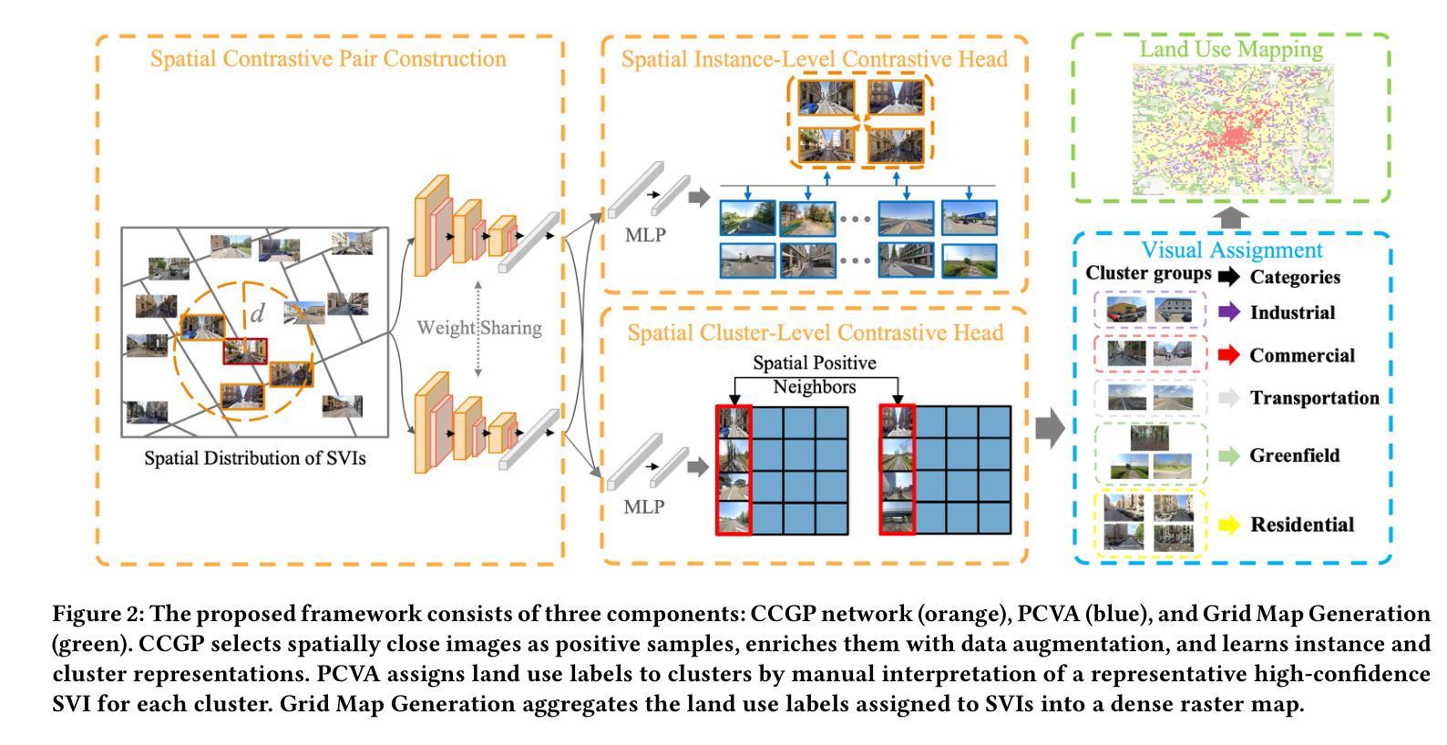
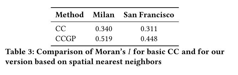
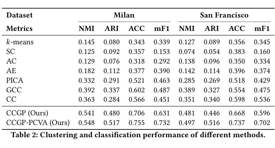
Urban land use classification and mapping are critical for urban planning, resource management, and environmental monitoring. Existing remote sensing techniques often lack precision in complex urban environments due to the absence of ground-level details. Unlike aerial perspectives, street view images provide a ground-level view that captures more human and social activities relevant to land use in complex urban scenes. Existing street view-based methods primarily rely on supervised classification, which is challenged by the scarcity of high-quality labeled data and the difficulty of generalizing across diverse urban landscapes. This study introduces an unsupervised contrastive clustering model for street view images with a built-in geographical prior, to enhance clustering performance. When combined with a simple visual assignment of the clusters, our approach offers a flexible and customizable solution to land use mapping, tailored to the specific needs of urban planners. We experimentally show that our method can generate land use maps from geotagged street view image datasets of two cities. As our methodology relies on the universal spatial coherence of geospatial data (“Tobler’s law”), it can be adapted to various settings where street view images are available, to enable scalable, unsupervised land use mapping and updating. The code will be available at https://github.com/lin102/CCGP.
城市土地利用分类和地图绘制对于城市规划、资源管理和环境监测至关重要。现有的遥感技术在复杂的城市环境中往往因缺乏地面细节而精度不足。不同于航空视角,街头影像提供了地面视角,能够捕捉到与土地利用相关的更多人类和社会活动在复杂的城市场景中的信息。目前基于街头影像的方法主要依赖于有监督分类,这面临着高质量标记数据稀缺和难以在多样化的城市景观中推广的挑战。本研究引入了一种无监督对比聚类模型,该模型针对街头影像具有内置的地理先验知识,以提高聚类性能。结合简单的集群视觉分配,我们的方法为土地利用制图提供了一种灵活且可定制的解决方案,可根据城市规划者的具体需求进行定制。实验表明,我们的方法能够生成两个城市的带地理标签的街头影像数据集的土地利用图。由于我们的方法依赖于地理空间数据的通用空间连贯性(Tobler定律),因此可以适应各种有街头影像数据的场景,以实现可扩展、无监督的土地利用制图和更新。代码将发布在https://github.com/lin102/CCGP。
论文及项目相关链接
PDF 11 pages, 7 figures, preprint version
Summary
本文提出了一种基于无监督对比聚类模型的街道景象图像分类方法,结合地理先验信息提高聚类性能。该方法通过简单视觉集群分配,为城市规划者提供灵活定制的土地利用映射解决方案。实验表明,该方法可从两个城市的带地理标签的街道视图图像数据集中生成土地利用图。该方法具有普适性,可适应各种场景,一旦获得街道视图图像,即可进行规模化、无监督的土地利用映射和更新。
Key Takeaways
- 现有遥感技术在复杂城市环境中存在精度不足的问题,缺乏地面细节信息。
- 街道视图图像可以提供地面视角,捕捉土地利用相关的更多人类和社会活动信息。
- 现有街道视图方法主要依赖监督分类,面临高质量标签数据稀缺和难以在多样化城市景观中推广的挑战。
- 本研究引入了一种基于无监督对比聚类模型的街道视图图像分类方法,结合地理先验信息提升性能。
- 该方法通过简单视觉集群分配,为城市规划者提供灵活定制的土地利用映射方案。
- 实验证明该方法可从两个城市的街道视图图像数据集中生成土地利用图。
点此查看论文截图